
It is said that the knowledge of Church history is a consolation. Most often this is meant in the sense that, for those who are troubled about the Church in the present age, all you have to do is look back at the history of the Church and you are sure to find an era that is as bad or worse than the present. I would suggest, however, that the consolation of Church history also applies to the good times. Reflecting on good times provides us with something to strive for and provides hope for the future. If we ourselves must suffer through the unhappiness of widespread laxity and apostasy, we can work for better times for future generations. In addition to being a theological virtue, the hope that the efforts of our lives will contribute to something better for our descendants serves the practical function of being a powerful motivator. It helps us through the grind of our daily work.
The most obvious examples of such better times, times that can serve as motivators for us, are the periods of great evangelization and the periods of great reform. We can look at the rapid spread of Christianity through pagan Rome in its first centuries. We can look at the rapid spread of the monastic reforms of Cluny and Citeaux (Cistercians) in the Middle Ages. Or we can look at the extensive missionary work of the Society of Jesus in Early Modernity, to cite just a few.
Yet, historical accounts of these periods can be somewhat abstract, especially for those of us with weak imaginations, and it helps to make use of visual aids. In particular, I find maps helpful. For example, it is known that in the 50-year period between 1098 when Saint Robert of Molesme founded the Abbey of Cîteaux and the death of Saint Bernard of Clairvaux in 1153, some 350 monasteries were founded or came under the Cistercian reform. A map of these monasteries (taken from here), including also the monasteries that came under the Cluniac reform, can be see below: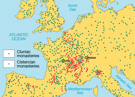
Ours is decidedly not among the good times. Nevertheless, I often hear from traditional Catholics that we are “winning”; that the changes of the 20th Century and the particular problems that have accompanied them will ultimately be consigned to the garbage can of history. Traditional Catholics have all the children. The children of traditional Catholics retain their faith into adulthood. Traditional Catholics support their Mass centers financially. Traditional Catholics believe in the teachings of the Church. And so forth.
I have been skeptical of claims that we are secretly “winning”. Too often such claims seem like polite fantasies we tell ourselves to keep our spirits up. I felt as though I needed more data, so I decided to build myself a map. I asked myself, what does the growth of traditional Catholicism look like from the foundation of the Society of Saint Pius X by Archbishop Marcel Lefebvre in 1970 to the present day, roughly the same period of time (50 years) as the major period of the Cistercian reforms depicted above?
The result of my efforts is the map below, built using tools available through Google Maps. Each point represents a location on Earth where the traditional form of a Latin (mostly Roman) Rite is regularly celebrated. The points are color coded: gray = Society of Saint Pius X, Blue = Fraternity of Saint Peter, Red = Institute of Christ the King, Black = Institute of the Good Shepherd, Yellow = various religious communities. The map is interactive, you can zoom in or out, scroll in any direction, and remove points by clicking on the “check marks” next to the community names on the left side. The information used to construct this map was collected from sources publicly available on the internet. This map is meant to be an illustration. It is not meant to be exhaustive and it is highly likely that I have excluded some localities accidentally, or included some localities where the Mass is no longer offered.
What does this map tell us? Most importantly, it tells us that a lot of work has been done in the past 50 years. In those years, we have managed, starting from very little, to bring the Mass of our ancestors to well over a thousand locations, all over the Earth. It seems definitive that we are in the midst of a reform, a reform not unlike those of past times. Yes, there is still a lot of mess that needs cleaning up. And, no, the reform may not yet have reached your doorstep. But, the reform is spreading. God has not forgotten us and we should be hopeful for the future. Not a hope of complacency, but a hope that motivates us to continue working, sacrificing, and suffering day in and day out to provide something better for our descendants.
Map in Detail
For those interested, a few further notes on the map. The term “regularly celebrated” includes frequencies such as “every Sunday”, but also frequencies such as “every second and fourth Sunday,” etc. This is especially true for many of the SSPX localities in Asia. Additionally, Mass may not be offered publicly at some of these localities on a regular basis. Some of these localities, especially SSPX localities in France, are houses of religious or priories which offer public Mass only infrequently.
Schools associated with traditional communities are not shown. Traditional communities that are officially or unofficially bi-ritual are not shown. Notable exceptions include the Norbertines in California and a number of Oratorian communities. These are all coded as yellow (religious). I know Oratorians are not religious, but it is convenient to think of them as such in this context.
This map excludes Latin Mass localities sponsored by diocesan priests. The reason for this is that information on such localities is often difficult to find and/or out of date. Diocesan Mass localities seem unfortunately ephemeral.
All localities shown here should be understood as general localities. That is, the localities are usually not accurate below the level of the city or town. This was done to save time (there are over a thousand points represented here and I have my own work to do as well). Additionally, exact street localities are not always given on websites, or are hard to find. This is particularly true of the SSPX, where each district appears to manage its own website and Mass localities are not given in a standardized way. Similarly, important localities, like “Paris”, may be represented by a single point, whereas multiple entities may be present. The SSPX, for example, has more than a half-dozen apostolates in Paris but there is only a single point on this map.
The SSPX Mass localities from the Caribbean are mostly not shown. That district has a website but no information on Mass localities is given. The SSPX Mass localities from the Eastern European district are not shown. That district has a website, but it is in Polish and I do not speak Polish. Monasteries and houses of religious associated with the SSPX (served by SSPX priests or given faculties by SSPX bishops) are colored as SSPX (gray) and not as religious (yellow).
It is my hope that the map I created can serve, at least informally, as a useful informational tool for Catholics trying to get an understanding of exactly what the geographic reality of the traditional Latin Mass movement looks like in real terms. I think that it demonstrates that traditional Catholics should be hopeful.
We may lose a lot of battles, but we are making real progress.